|
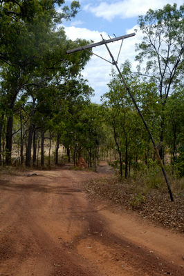
Overland Telegraph Line Track The Overland Telegraph Line Track or more commonly referred to as the OTL track or simply just the OTL runs right up the heart of the peninsula. This is the traditional route for those wishing to explore the Cape and it follows the Overland Telegraph Line that was once the only method of communication for those living on the peninsula. The Telegraph operated from 1885 until 1964 when the last message was sent. The route was still used for telephone cable until 1987 when it was finally dismantled. Today the poles are still in place, many of which are still standing, and it is along this route that the track north follows.
The OTL track is very simply a rough road, passable only during the Dry season. Even late in the Dry, creek crossings are numerous and some are quite hazardous. Road conditions vary tremendously with rainfall, roadwork, and traffic but while I was there everything seemed to be in reasonable shape. Today, there are two bypass roads
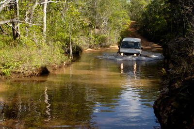
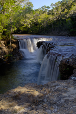
There are three main reasons to take the OTL rather than the faster bypass roads, adventure, tradition, and scenery. As mentioned before, the OTL is the traditional route up and down the Cape and for much of the Cape’s history, the only possible route. The OTL winds along through beautiful country, across crystal clear creeks and rivers, and past numerous waterfalls while the Bypass Roads are rather large and dusty and traverse mostly through the highlands to the east and west of the route. Finally, there is definitely a bit of adventure in the track. I know that I personally was looking forward to the challenge of driving this road and having to ford streams and creeks, something I had never done before.
I left Weipa early on September 22nd and headed north with the goal of reaching Eliot/Twin Falls by evening. By about 11:00 that morning, I had made it to Bramwell Junction where the OTL really begins and I headed off. Almost immediately I came to my first real creek crossing at Palm Creek and got across without any problems. This was just the first of many crossings and I grew to enjoy them even though some of the more complicated ones made me a bit nervous. From Bramwell Junction to the Eliot/Twin Falls area was about 80 km and it would take me well over four hours to cover that distance. The driving was without any major incidents, and while bumpy and quite uneven, it went smoothly. I was fortunate to have all of my stuff in the back lashed down securely so everything was intact and in place when I arrived at Eliot Falls just after 4:00 that evening.
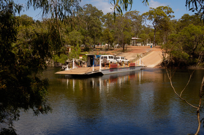
In this area, managed by the Heathlands Reserve there are two sets of waterfalls on Canal and Eliot Creeks just before they converge. There is quite a nice campground set up here and while it is apparently crowded much of the time, the evening I spent here was quite nice and not very crowded. I was able to photograph the falls in the evening and again in the morning before I hit the road again. North of Eliot Falls, I had two more creek crossings before I cut over to the Northern Bypass Road and eventually the Jardine River ferry. The ferry is pretty much a requisite as at the Jardine River is a wide river and can be quite treacherous to ford and rarely anyone ever does it anymore. From the Jardine River to Bamaga and the surrounding community was uneventful and I had officially made it to the top!
|

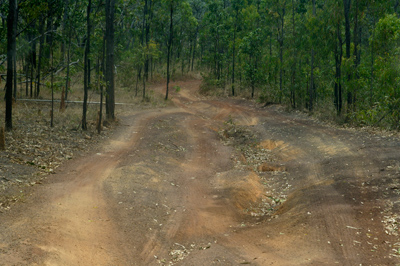
 that allow travelers to get from the Peninsula Development Road to the tip without having to navigate all of the creek crossings and rough roads but these roads themselves are not so easy going. They are heavily corrugated making for a very rough drive and the vibrations of these corrugations can often cause just as much car trouble as the rough road up the OTL. Most visitors, myself included, take the OTL track north and return via the Bypass roads.